US Topo Maps Pro 6.7.1
Paid Version
Publisher Description
Easy to use outdoor/offline navigation app with free access to the best topographic maps and aerial images for the USA.
Turn your Andoid Phone/Tablet into an outdoor GPS for trips into the backcountry without cell coverage. This app gives you similar mapping options as you might know from GPS handhelds.
Premium email support - we'll answer your questions within 24 hours
Main features for outdoor-navigation:
• Download of map tiles for OFFLINE USAGE (not for Google and Bing maps)
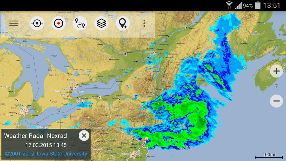
• Display Real-Time nowCoast Weather Information and NEXRAD Weather Radar (animated)
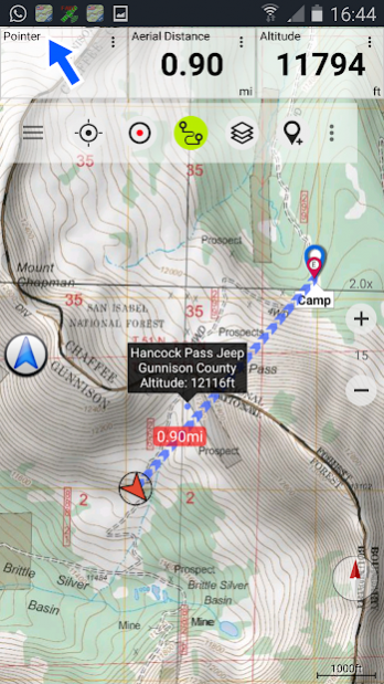
• Free access to more than 100.000 seamlessly stitched USGS topographic maps - easy to use as browsable map layer
• Create and edit Waypoints
• GoTo-Waypoint-Navigation
• Create and edit Routes
• Route-Navigation (Point-to-Point Navigation)
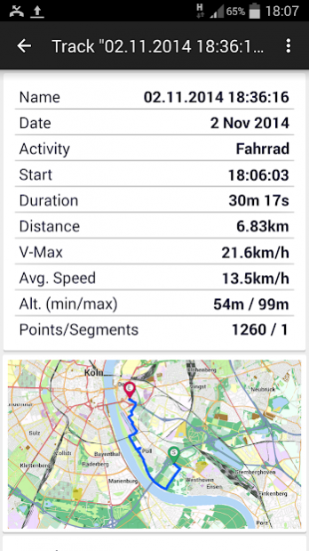
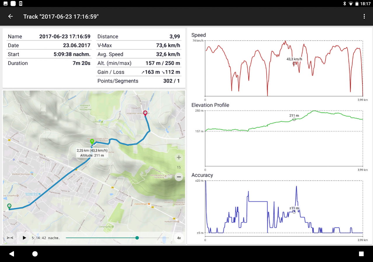
• Track Recording (with speed, elevation and accuracy profile)
• Tripmaster with fields for odometer, average speed, bearing, elevation, etc.
• GPX/KML/KMZ Import/Export
• Search (placenames, POIs, streets)
• Customizable datafields in Map View and Tripmaster (e.g. Speed, Distance, Compass, ...)
• Share Waypoints, Tracks or Routes (via eMail, Dropbox, Facebook, ..)
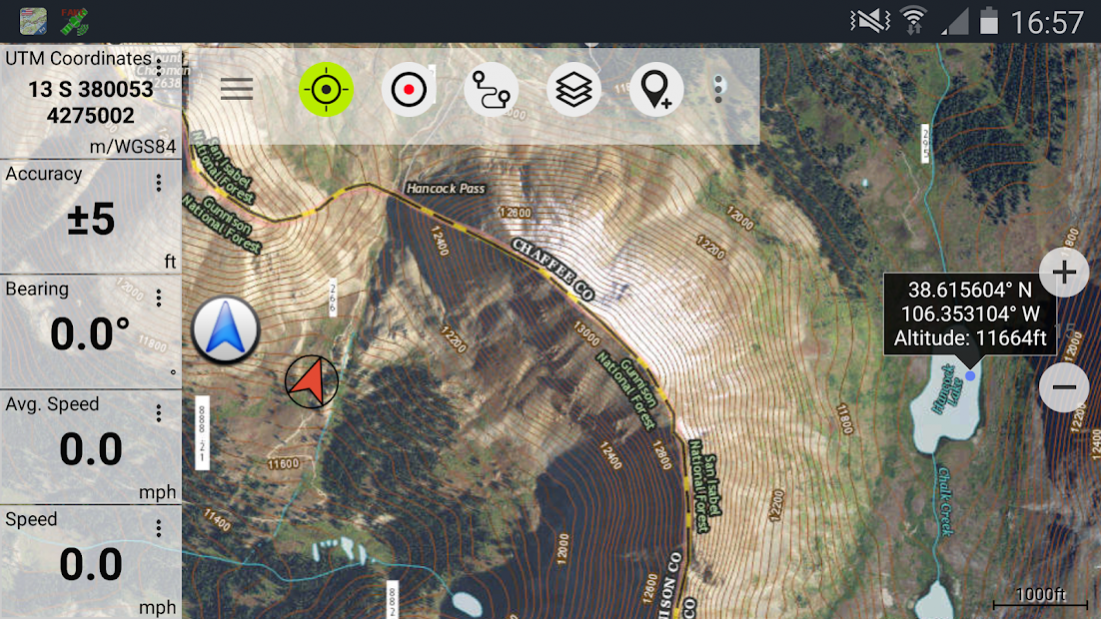
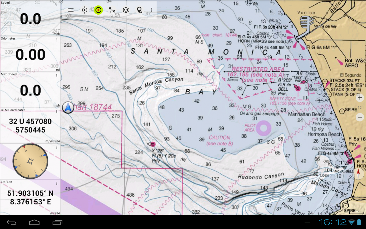
• Use coordinates in WGS84, UTM or MGRS/USNG (Military Grid/ US National Grid)
• Get NWS Weather Forecast
• Track Replay
• and many more ...
Available map layers:
• USGS DRGs: Seamless coverage of topo maps of the USA at Scales 1:250.000, 1:100.000, 1:63.000 and 1:24.000/25.000
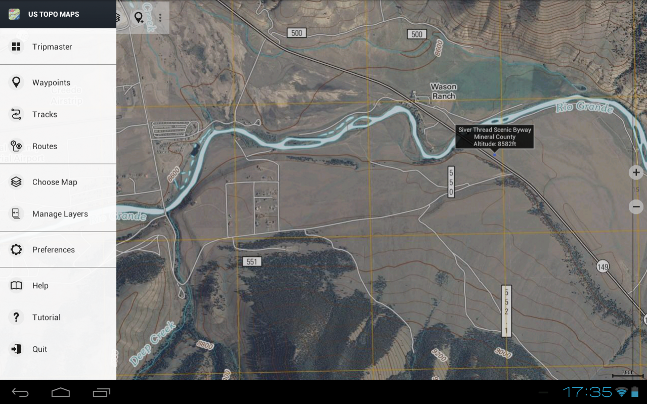
• New US Topo maps
• USGS High Resolution aerial imagery
• USGS National Map
• NAIP Orthoimagery for conterminous US
• Google Maps (Satellite images, Road- and Terrain-Map)
• Bing Maps
• Open Street Maps
• FSTopo Forest Maps
• NOAA Nautical RNC Charts
• Flight Maps
• Public Land Ownership (Padus)
• Earth At Night
Available map overlays:
• Hillshading
• Ridge Weather Radar NWS
• Wind, Temperature, Pressure
• Wind Vectors
• Precipitation Estimate - 1-hr
• Precipitation Forecast 24h
• Surface Air Temperature
• Hazard Warnings
• Tropical Cyclone Track
• Wind Vector Forecast 24h
• Max. Air Forecast 24h
• Min. Air Forecast 24h
USGS DRG topographic maps:
The 7.5-minute maps (1:24.000/1:25.000) are the best maps for outdoor activities in the USA. Although some of the maps are quite old, they contain many small pathes and 4WD tracks that are missing in new USTopos, Google, Bing and OSM maps.
DRGs (Digital Raster Graphics) were produced from 1995 to 2001 by U.S. Geological Survey. DRGs have been made for all quadrangles in the USGS map series.
New US Topo Maps:
US Topo maps are a graphic synthesis of The National Map data files and are produced in the familiar 7.5-minute by 7.5- minute geographic format. Current US Topo map layers include an orthoimage base, transportation, geographic names, topographic contours, boundaries, hydrography and woodlands. Also included are the Public Land Survey System (PLSS) and the United States National Grid.
NAIP Orthoimagery:
Seamless coverage of contiguous US with 1m/pixel resolution
HRO aerial imagery:
High resolution arial photos covering US urban areas and borders (up to 10cm/pixel)
Use this navigation app for outdoor activities like hiking, biking, camping, climbing, riding, skiing, canoeing, hunting, offroad 4WD tours or search&rescue (SAR).
Import/Export/Share GPS-Waypoints/Tracks/Routes in GPX or Google Earth KML/KMZ format.
View Real-time nowCoast weather information like temperature or windvectors and overlay to map.
See animated NEXRAD rain radar to make accurate predictions when raining will start/stop.
Preload FREE map data for areas without cell service.
US topographic maps are enhanced with Atlogis® hillshading and placenames.
Free version available.
Comments and feature requests to usmaps@atlogis.com
About US Topo Maps Pro
US Topo Maps Pro is a paid app for Android published in the Geography list of apps, part of Education.
The company that develops US Topo Maps Pro is ATLOGIS Geoinformatics GmbH & Co. KG. The latest version released by its developer is 6.7.1. This app was rated by 1 users of our site and has an average rating of 4.0.
To install US Topo Maps Pro on your Android device, just click the green Continue To App button above to start the installation process. The app is listed on our website since 2021-12-14 and was downloaded 17 times. We have already checked if the download link is safe, however for your own protection we recommend that you scan the downloaded app with your antivirus. Your antivirus may detect the US Topo Maps Pro as malware as malware if the download link to com.atlogis.northamerica is broken.
How to install US Topo Maps Pro on your Android device:
- Click on the Continue To App button on our website. This will redirect you to Google Play.
- Once the US Topo Maps Pro is shown in the Google Play listing of your Android device, you can start its download and installation. Tap on the Install button located below the search bar and to the right of the app icon.
- A pop-up window with the permissions required by US Topo Maps Pro will be shown. Click on Accept to continue the process.
- US Topo Maps Pro will be downloaded onto your device, displaying a progress. Once the download completes, the installation will start and you'll get a notification after the installation is finished.
